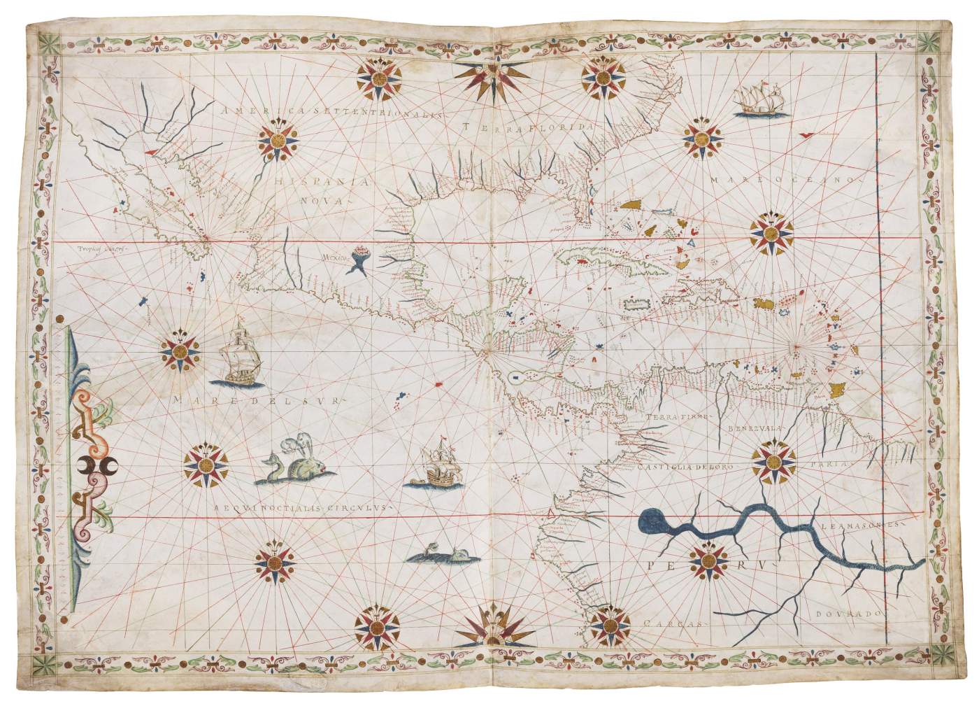
Magnificent Portolan chart of Central America
Joan Oliva, Italy, c. 1585-1595
Central America, southern part of North America, northern part of South America, coastlines and seas. The latitude scale indicates north/south coverage from 11° S to 39° N. The centre is located at a latitude of about 14° N near San Salvador, the present day capital of El Salvador. – The Catalan Joan Oliva was the best cartographer of his days. Since sailors and merchants jealously guarded geographic information so as not to endanger their trading monopolies, such charts had limited circulation. As the overall survival rate of historic charts was extremely low, they not often come to the market today. Lavishly heightened with gold and fine decoration, the present chart was part of a de luxe commission.
This map has been sold.
%3Cdiv%20class%3D%22artist%22%3E%3Cspan%20class%3D%22artist%22%3E%3Cstrong%3EJoan%20Oliva%3C%2Fstrong%3E%3C%2Fspan%3E%3C%2Fdiv%3E%0D%3Cdiv%20class%3D%22title%22%3E%3Cem%3EMagnificent%20Portolan%20chart%20of%20Central%20America%3C%2Fem%3E%2C%20c.%201585-1595%3C%2Fdiv%3E%0D%3Cdiv%20class%3D%22medium%22%3EIlluminated%20manuscript%20portolan%20chart%2C%20tempera%20and%20gold%20on%20vellum%3C%2Fdiv%3E%0D%3Cdiv%20class%3D%22dimensions%22%3E525%20x%20740%20mm.%20%E2%80%93%20Border%20with%20ornaments%20of%20alternating%20green%20and%20pink%20geometric%20shapes%20on%20the%20four%20edges%2C%20and%20green%20stars%20on%20each%20corner%2C%20decorative%20scale%20bar%20in%20the%20south-western%20corner.%20%3C%2Fdiv%3E
Illuminated manuscript portolan chart, tempera and gold on vellum
525 x 740 mm. – Border with ornaments of alternating green and pink geometric shapes on the four edges, and green stars on each corner, decorative scale bar in the south-western corner.
Celebrating the age of exploration
Overview
The chart is oriented with North to the top. It covers the western part of the North Atlantic Ocean, Caribbean Sea, Gulf of Mexico, eastern part of the Pacific Ocean, Sea of Cortes; Bermuda, Cuba, Hispaniola, Puerto Rico, other Caribbean islands; coasts of North America, Central America, Venezuela, Colombia, Peru. This chart exhibits the improving picture of the New World typical of the second half of the 16th century: Baja California on a NW/SE axis; Yucatan depicted as a peninsula rather than an island; no exaggerated westerly bulge on the west coast of South America; Cuba and the Caribbean islands are placed at correct latitudes vis-a-vis the Tropic of Cancer. The east/west dimension of North America is significantly exaggerated, but this is typical of most maps and charts of this period. The decoration consists of twelve compass roses and two half roses with the four directions in the northwest and southwest corner, all with a fleur-de-lys. The seas contain monsters, ships under sail, one of which with a barge on a line. The large rivers are painted in blue. A vignette shows Mexico City on its lake.