Erhard Etzlaub
The Road to Rome: Rom Weg Map
Germany, Nuremberg, c. 1500
A rare variant of the famous 'Rom weg' map. – The present map shows the routes from northern Europe to Rome. It is oriented from south to north, with Rome and Naples at the upper edge, Denmark at the lower edge, and Nuremberg in the centre. The routes to Rome are marked as lines of small dashes, each representing a German mile. As a broadside, the map is easy to carry. The text is in German, and the geographical accuracy excels all preceding maps. With such practical features, the Rom weg map is regarded the first ever printed travel map.
This work has been sold.
%3Cdiv%20class%3D%22title%22%3E%3Cem%3EThe%20Road%20to%20Rome%3A%20Rom%20Weg%20Map%3C%2Fem%3E%2C%20c.%201500%3C%2Fdiv%3E%0D%3Cdiv%20class%3D%22medium%22%3ESingle-leaf%20woodcut%20on%20paper.%20Watermark%3A%20Bull%E2%80%99s%20head.%3C%2Fdiv%3E%0D%3Cdiv%20class%3D%22dimensions%22%3E422%20x%20304%20mm.%20%E2%80%93%20Single%20sheet%20print%20with%20woodcut%20map%20and%20xylographic%20text%2C%20coloured%20by%20a%20contemporary%20hand.%3C%2Fdiv%3E
Single-leaf woodcut on paper. Watermark: Bull’s head.
422 x 304 mm. – Single sheet print with woodcut map and xylographic text, coloured by a contemporary hand.
The first ever printed road map – an extremely rare broadside
Overview
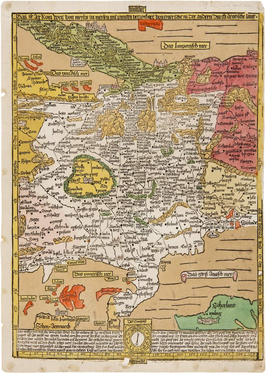
As compass maker, cartographer, and astronomer, Erhard Etzlaub (c. 1460-1532) made crucial contributions to the development of regional cartography.
In 1500, a Christian Jubilee year, pilgrims from all corners of Europe flocked to Rome. It is clear that this map was created for exactly this purpose – a guide map for pilgrims. It is thus generally dated about 1500 or slightly earlier. Etzlaub's Rom weg map was certainly a great success. It was printed in great quantities, the present copy was most probably produced in the same year.
Altogether 13 copies of the Rom weg map are known in two variants only slightly deviating from each other, i.e. they were printed from two different woodblocks. The present copy was printed from the second block. It is thus a contemporary, very close and exact copy of the first map in an early stage. This version survived in only three copies.